Starting at Bunker Hill Road and ending at Undermountain Rd, Salisbury CT. We did a mix of Blue Trails and the Appalachian Trail ~8.83 miles at 5.75 hrs with breaks for views.
Bear Mountain is the highest peak in CT at 2,323 feet. It’s one of the hikes, (similar to Sleeping Giant), that if you’re from CT and admit that you haven’t climbed it, people will ask / exclaim, “You haven’t hiked Bear Mountain?!?” Well, I can finally say that I have, and thanks to my friend Katie, I did one better and also hiked Lion’s Head!
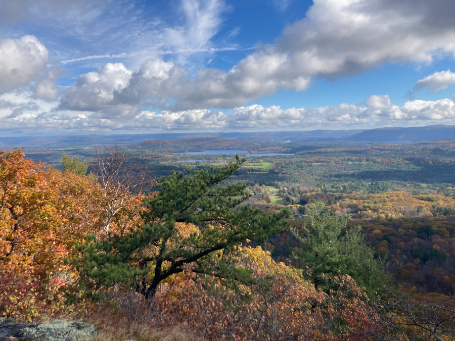
Today’s hike was just simply gorgeous. I really wanted to experience Bear Mountain with the full colors of fall and Mother Nature delivered! The only unfortunate part of the hike was that it had rained quite a bit the day before so there were some dangerous areas — especially coming down Bear Mtn. with wet slippery rocks.
We started at the hikers parking lot at Bunker Hill Road for Mt Riga State Park. Heading up to Lion’s Head you start on a blue trail that turns into the Appalachian in just under a mile. The peak is 1,738 feet and from the parking lot you get a nice little flat trail to the woods. Once there it goes straight up for about 1,000 ft. The terrain is an easy mix of woods and rocks and although it is a short hike — it is steep. The views are breathtaking and I wouldn’t have minded staying there all day.
Continuing on the Appalachian Trail we headed for Bear Mountain, not before spotting a baby red ring neck snake (killer) in the middle of the trail. Using a leaf, Dana and Ryan nicely moved him off of the trail so he wouldn’t scare anybody else and also so he wouldn’t get squished. Hopefully this was the last danger noodle until spring ’22— what am I saying? Hopefully it is the last nope rope ever!
So we continued on. The trail from here is a mix of woods and rocks and streams with small ups and downs and a few lookout points a long the way. A few of the wet rocks make perfect little slides so careful foot work was in order, or in my case the crabwalk.
We passed two camps along the way and we took one side trail to check out the Riga Shelter. You get to cross a pretty stream before coming to the campsite. I definitely want to stay here. The leanto faces a beautiful lookout facing east. Ryan pointed out the irony of how people put their food in a bear box yet sleep in the open or in a tent. We were also curious as to what made the scratches on the bear box???
Heading back to the main trail we continued on for approximately 50 mins before coming to the trail to Bear Mountain summit. Here you go up, and up and up, come to a false summit, and go up some more. The trail starts as a mainly dirt path and quickly changes to a mix of rocks and dirt to just metamorphic rock, back to a mix. If it wasn’t wet it would be a breeze to climb but wet rocks demanded careful footwork.
Once we reached the summit there was a cairn that makes the summit just a little bit higher. We took in the views and sat on top of the cairn for awhile with some trail mix and water. I have to say that it is very impressive but Lion’s Head did have a prettier view. It also got really cold really quickly while sitting up there.
We all put our layers back on and started the descent. Before we got to the “tricky part” we passed a man who had just come up it. He warned us that he wouldn’t go down and that he would recommend us turning back. We politely thanked him but of course decided we would judge it for ourselves.
The climb down was not only steep but it was wet. Some of the rocks made natural stair steps and some made slides. We all went really slowly and just took deliberate steps always looking for a solid tree to grab onto or to stop us if we fell. (Any pics after the summit that look like they are going up hill was actually me turning around to snap a picture of what we just came down.) I am not an adrenaline junky and because of the slippery rocks I didn’t like this section at all. At one point my knees were feeling shaky and I wanted to will myself to another place (damn my lack of magic). I resorted to sitting in many a wet area to slide / climb down. Fortunately we all made it down without falling.
The trail returned to a gently-sloping wooded and rock path that took us to the sign for Sage’s Ravine (my phone died here) and then onto Paradise Lane Trail to Undermountain Trail. It took us another 1.75 hrs to get back to the car. But not before I slipped on a rock and took a digger. Of all the places to fall it was pretty safe because it was not by an edge, but it was hard as I literally threw my body onto solid rock. I busted one knee and strained so many muscles. Later Ryan confirmed why my ribs hurt as he noted that I landed on my aluminum travel mug (yes, the same one proudly pictured for forest coffee with a view). Even though I “fell like Jello,” I am going to feel this one for a few days.


Adventurers included: Jes, Ryan, Dana, Bryan & Dogo