Lost River Rd, North Woodstock, NH 03262 ~ 3.3 miles and 3.5hrs
Before going, we knew we were picking the hardest trail up Moosilauke, but the waterfall and the views seemed worth it. I read that it could be a very dangerous trail due to slippery wet rocks and that the first two miles were incredibly steep followed by a gradual climb to the summit. We also read that it was still icy so we were prepared with micro spikes.
We agreed no matter what, safety came first, and understood that as much as it would metaphorically kill us not to summit, we would much rather deal with that than contend with literal injury or death.
Unfortunately due to forecasted rain for the rest of the weekend, we were forced to “cram” in our hike on Friday. We didn’t get started until about 1:50 PM. The late start was our main reason for not summiting — but they are not joking when they say the trail gets steep! Due to the snow and ice we weren’t going fast but my heart was still pounding out of my chest. This from a woman who normally “runs” uphill.
The very start of the trail is actually flat. There were patches of ice, snow, mud, and leaves. Right away we had to cross over two fallen logs to pass over water. The thinner log was only able to support one’s weight for 75% of its length. Once at that point one had to shift their weight and feet to the thicker log. Only one of these logs remains in place because someone stepped too far on the skinny log and it fell.
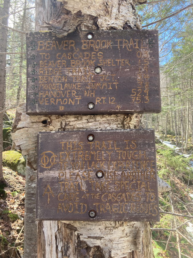
For the first ten minutes or so the trail is easy. Jump over a few streams, avoid stepping on ice, watch out for mud — the usual. Then we came to the sign that warns hikers to turn back if you are not prepared for this.
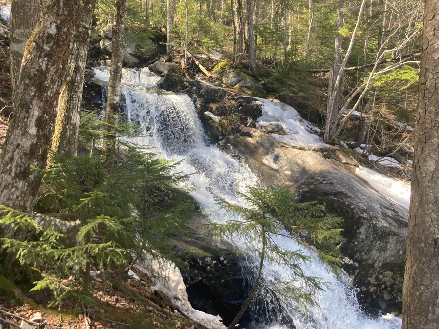
From here the climbing begins and the views of the gorgeous waterfall also begin. Due to the ice, it was definitely a tricky climb. The micro spikes were what made climbing possible, but the mix of slush and unpacked snow made for fancy footwork with almost every step.
The waterfall is stunning and the water rushing was very loud but soothing.
After climbing slippery steep ice / slush for an hour and forty mins, we made the decision to turn back. According to the sign on the tree where we made the decision, the Beaver Brook Shelter was only 0.25 miles away, which means we probably had another .75 miles of steep climb before the 2 “relaxing” miles to the summit. We were moving so slowly going up that I got scared about running out of sunlight and trying to come down the ice in the dark sounded horrific. We both agreed, and turned back to try another day.
Coming down was trickier than going up. There were a couple of sections that intimidated me to the point that I noped-out and we made a small detour through the woods.
We were both post-holing, but leave it to me to post hole so good that I got stuck. It was in a steep section so my foot naturally went forward and the weight of ~ three feet of snow had my foot lodged in place. Mike had to dig me out. I also slid down a section of the trail right toward the edge. Fortunately I managed to stop myself by hitting my feet into a tree. My phone took a ride down the hill too, but again, fortunately it landed in a little hole instead of sliding into the waterfall. Mike didn’t seem to have my issues… which is good because we can’t have two klutzes on the trail. We made it safely down around 5:19 and were still smiling.
To be continued…


Adventurers included: Jes & Mike